facebook
Image showing that the PDF download is in progress... PDF download in progress

Please wait...

Image showing a pink decorative paint splat
Image showing a green decorative paint splat
Trail Image upload photo button

NOTE: This adventure is in Glass House Mountains National Park for current Queensland Parks and Wildlife Service parks information, maps and essential park alerts click here

reviews buttonReviews view map buttonMap
view 3d map button3D Map
directions take me there buttonDirections
Save
PDF
Gpx File

Glass House Mountains National Park: Mt Beerburrum Summit Walk

Glass House Mountains National Park: Mt Beerburrum Summit Walk
Beerburrum
walking icon walking icon black
Trail type
difficulty icon
Skill Level
1.7km
One-way Length
direction icon direction icon black
One-way

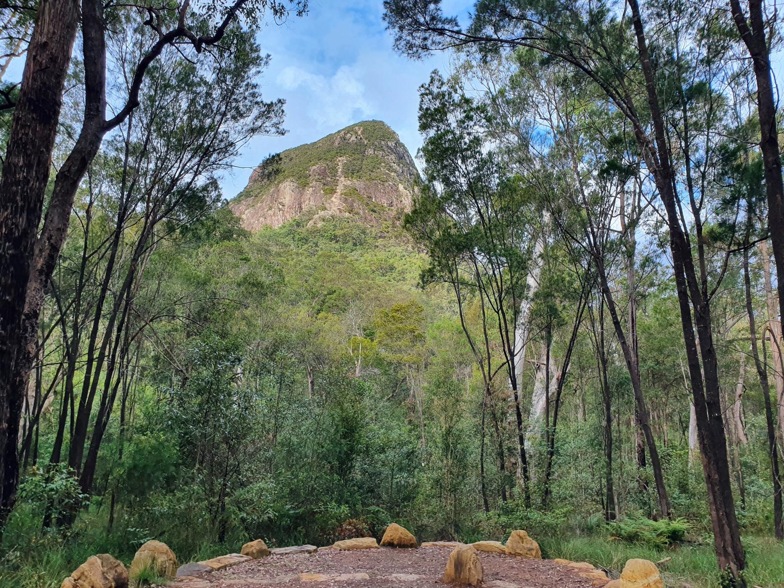
Enjoy 360 degree views from a fire lookout platform atop of this Glass House Mountain summit.

SUITABILITY
Suitable for walkers with strong legs / some stamina.

HIGHLIGHTS
If you thought Wild Horse Mountain was hard on your calves, wait till you try this one. The path itself is an impressive bit of road building. It provides access to a fire look-out on top of Mt. Beerburrum that is manned during high fire danger conditions to keep and eye on the surrounding forestry area.

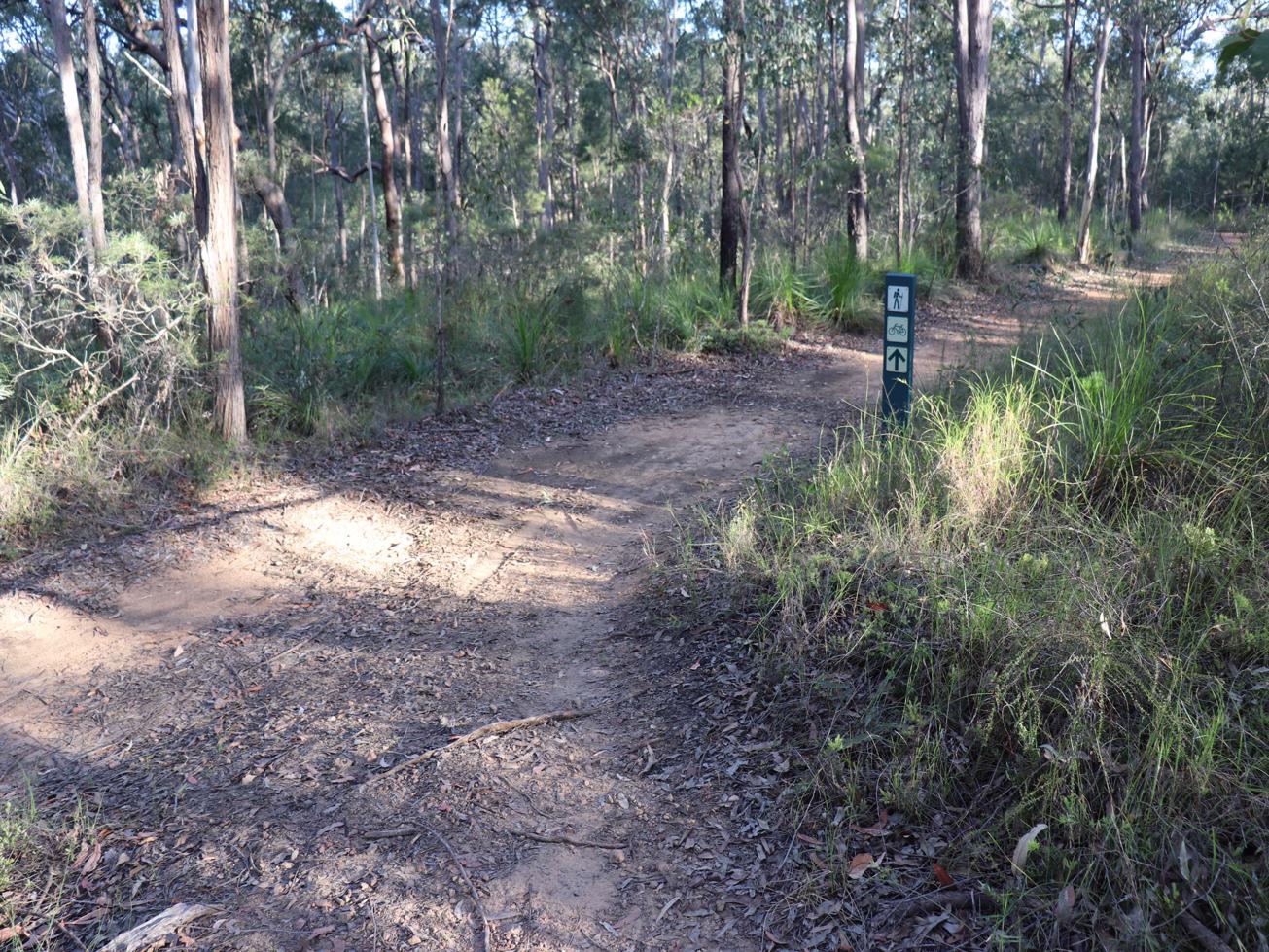
From the new trail head signage in the state school car park it’s a nice walk up thru a gully on the side of the mountain until you get to the old trail head from here the cement path begins. There is a giant Strangler figure to admire and rest in its shade before starting the real climb.

The plus about this walk is its paved over the last 200 metres to the summit and there is a great stone seat and viewing spot halfway up. The view from the top is not bad either. Climb the fire lookout platform to the first deck and take your time looking in each direction. You’ll discover that Matthew Flinders, along with his indigenous guide, Bongaree, and two seamen, climbed Mt Beerburrum, in 1799.

AFTERWARDS
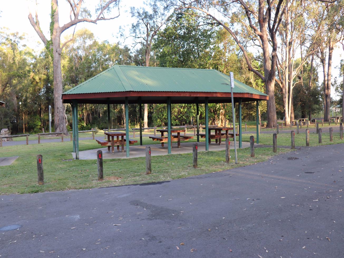
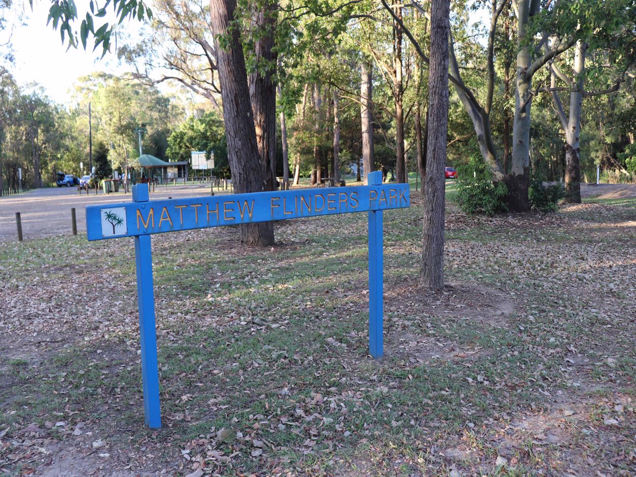
As you return to the Beerburrum school car park, why not follow the Soldiers Settlers' Trail to the Old Beerburrum Cemetery. You can continue on this trail to do a circuit out to Matthew Flinders park and come back to Beerburrum via the Old North Coast Road.

For refreshments there is Coffee right there in Beerburrum township and another cafe which serves great coffees and lunches in a lovely setting is not far away on Steve Irwin Way.

HOW TO GET THERE
To the starting point: Heading South on Steve Irwin Way turn right into Beerburrum Road (Beerburrum township).
Heading north on the M1/ Bruce Highway, take Steve Irwin Way and approx. 5 km later you will turn into Beerburrum Rd.

On Beerburrum Road you'll shortly pass the railway line, Parrot Park and the Beerburrum School. Turn right here where you see the blue cemetery sign and park in the car park next to the school. Look for the trails head signage and follow the trail to the summit from there.

The nearest public’s toilets are at Parrot Park, close by in Beerburrum to pop into before or after the walk.

To the end point: It’s the same as your starting point – this is an up and back route.

glossary button
Glossary
  • Icon showing this activity is suitable for wheelchairsSuitable for wheelchairs
  • Icon showing this activity is suitable for walkingSuitable for walking
  • Icon showing this activity is suitable for recreational cyclingSuitable for recreational cycling
  • Icon showing this activity is suitable for mountain bikingSuitable for mountain biking
  • Icon showing this activity is suitable for horse ridingSuitable for horse riding
  • Icon showing this activity is suitable for kayakingSuitable for kayaking
  • Icon showing this activity has drinking water availableDrinking water available
  • Icon showing this activity does not have drinking water availableNo drinking water available
  • Icon showing this activity has a barbeque on siteBarbeque on site
  • Icon showing this activity has a picnic table on sitePicnic table on site
  • Icon showing this activity has toilets on siteToilets on site
  • Icon showing fires are permitted at this activityFires permitted
  • Icon showing fires are prohibited at this activityFires prohibited
  • Icon showing camping is permitted at this activityCamping permitted
  • Icon showing camping is prohibited at this activityCamping prohibited
  • Suitable for walking Suitable for walking black lines Suitable for walking
  • No drinking water available No drinking water available No drinking water available
  • Fires prohibited Fires prohibited Fires prohibited
  • Camping prohibited Camping prohibited Camping prohibited
Write a review

Be the first to review this trail.

hazard icon

IN AN EMERGENCY DIAL '000'.

Always Adventure Safely!

  • Always follow any local signage, it contains key information and conditions can change at any time.
  • Use the trails with consideration for your abilities, be prepared for the adventure ahead:
    • Be aware of the weather conditions, found here: http://www.bom.gov.au/qld/.
    • Always wear appropriate clothing, focus on good footwear.
    • Always bring more water than you think you will need.
    • Be Sun Safe!
    • Always let someone know where you are going that isn’t going with you.
  • Just getting started try this site for good useful information: https://www.trailhiking.com.au/hike-safety/
  • Sunshine Coast Council does it’s best to maintain current information but things can change so always be aware that a trail may not be as listed in this guide, and report and issues via our feedback link.

Qld Parks and Wildlife Service

National Parks, Conservation Parks and some State Forests are managed by Queensland Parks and Wildlife Service. Contact details are: https://www.des.qld.gov.au/contactus/

For current information on trail conditions and alerts go to https://parks.des.qld.gov.au/park-alerts/#sunshinecoast

If you think something on this web site needs to change please let us know via: adventure@sunshinecoast.qld.gov.au

Nearby Trails

Trail Image for Glass House Mountains National Park: Yul-yan-man Track
Difficult

Glass House Mountains National Park: Yul-yan-man Track

Beerburrum
walking icon
Trail type
difficulty icon
Skill Level

9.2km

Length
direction icon
Circuit
Trail Image for Glass House Mountains National Park: Soldier Settlers Loop
Intermediate

Glass House Mountains National Park: Soldier Settlers Loop

Beerburrum
walking icon mountain biking icon
Trail type
difficulty icon
Skill Level

8.5km

Length
direction icon
Circuit
Trail Image for Glass House Mountains National Park: Mathew Flinders Park to Jack Ferris Lookout
Easy

Glass House Mountains National Park: Mathew Flinders Park to Jack Ferris Lookout

Beerburrum
walking icon
Trail type
difficulty icon
Skill Level

4.4km

Length
direction icon
One-way
Trail Image for Glass House Mountains National Park: Trachyte Circuit
Intermediate

Glass House Mountains National Park: Trachyte Circuit

Beerburrum
walking icon
Trail type
difficulty icon
Skill Level

6.4km

Length
direction icon
Circuit
Trail Image for Glass House Mountains National Park: Tibrogargan Circuit
Intermediate

Glass House Mountains National Park: Tibrogargan Circuit

Glass House Mountains
walking icon
Trail type
difficulty icon
Skill Level

4.6km

Length
direction icon
Circuit

Share this trail

This action requires a login.
To continue, click on Login/Signup below.

Photo uploaded successfully, thank you.

Feedback / Suggest an Adventure

If you have any feedback on the site or any of the trails, please drop us a short email.

Have we missed something? Do you have an adventure to suggest? Fill in the suggestion form to let us know about it.