facebook
Image showing that the PDF download is in progress... PDF download in progress

Please wait...

Image showing a pink decorative paint splat
Image showing a green decorative paint splat

NOTE: This adventure is in Mapleton National Park for current Queensland Parks and Wildlife Service parks information, maps and essential park alerts click here

reviews buttonReviews view map buttonMap
view 3d map button3D Map
directions take me there buttonDirections
Save
PDF
Gpx File

Mapleton National Park: Gheerulla Short Loop

Mapleton National Park: Gheerulla Short Loop
Gheerulla
walking icon walking icon black
Trail type
difficulty icon
Skill Level
2.3km
Length
direction icon direction icon black
Circuit

Enjoy a small bush walk in this section of Mapleton National Park between Kenilworth and Eumundi.

SUITABILITY
Suitable for walkers and mountain bikers – just be on the lookout for trail bike riders.

HIGHLIGHTS
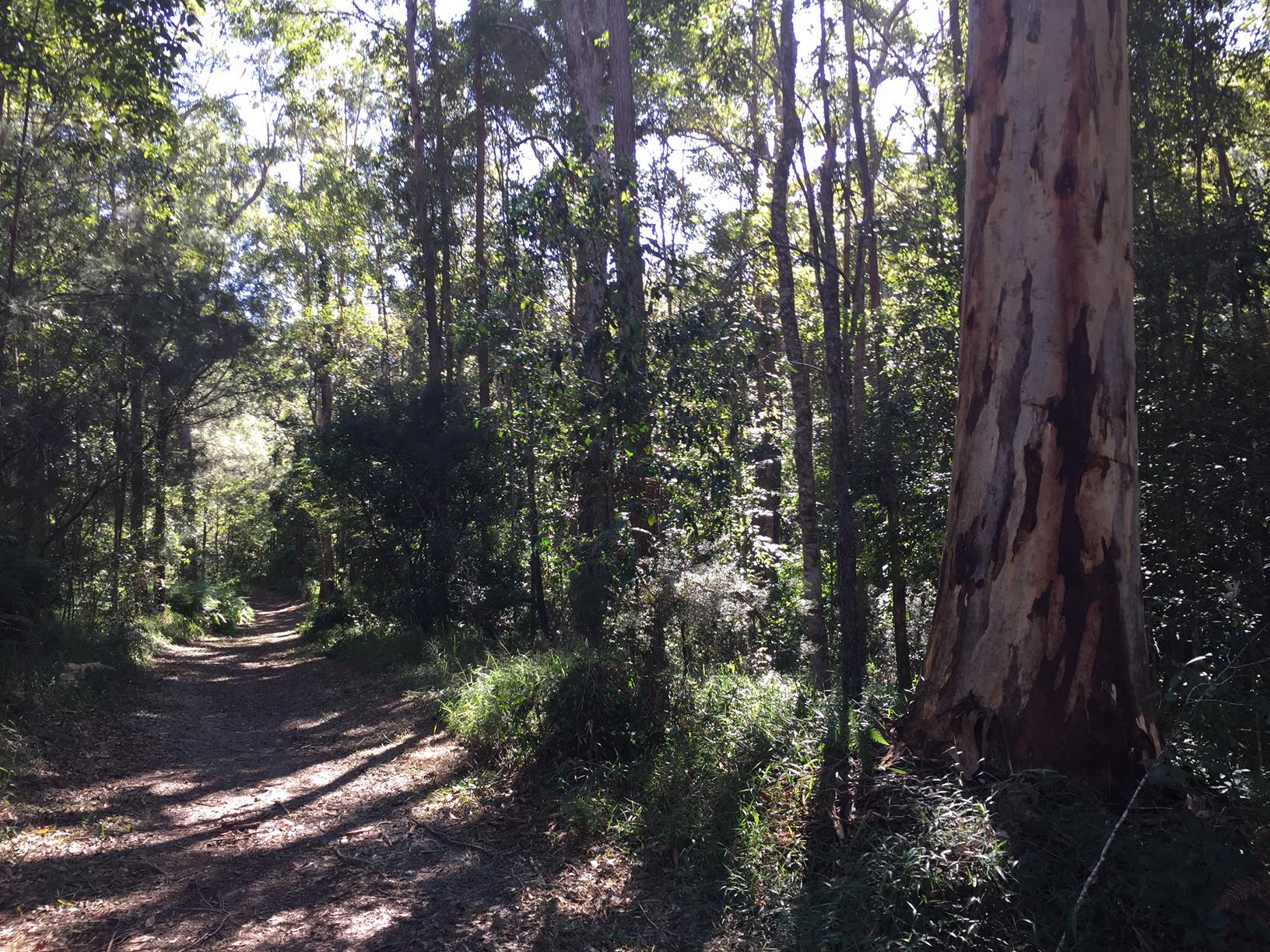
On Sam Kelly road just before the dirtbike carpark and campsite, there is a dry (usually) creek crossing to a lovely little forestry loop that’s fun for mountain biking or a brisk walk.
The creek here comes all the way from Gheerulla Falls at the top of the Blackall Mountain range. Hilly terrain, open forest and scribbly gum are features of the Mapleton National Park forest in this section.

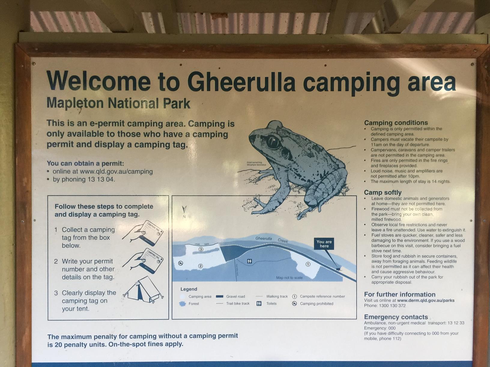
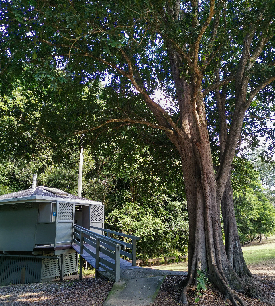
The small campsite has some amenities and provides access to the 58km Sunshine Coast Hinterland Great Walk. Plus, there are also 26 km of Trail Bike Tracks in this area – also accessed from campground – so just listen out for motorbikes in case there are any.

You might find frogs in the creek after it has rained, however it is easier to access this walk if it is dry (and hasn’t rained).

AFTERWARDS
Pop back into Kenilworth and enjoy one of their famous meat pies or cheese selections from the cheese factory. There are other walks to be enjoyed south of Kenilworth at Cambroon or head to Imbil State Forest for some longer walks.

HOW TO GET THERE
To the starting point: Heading north on the M1, take the Eumundi turnoff and the road to Kenilworth. About 25 kilometres later you will come to Sam Kelly Road on your left, a single lane dirt road.

From Kenilworth, it’s approximately 7.5 km, with the turn off on your right.

Follow this dirt road for approximately 1.5 km when you will cross a cattle grid. Park right by the National Park sign. The marked trail starts here off the right hand side. (The drive to the campground is beyond here but 4WD is recommended)

To the end point: The end point is the same as the starting point as it’s a small circular route.

glossary button
Glossary
  • Icon showing this activity is suitable for wheelchairsSuitable for wheelchairs
  • Icon showing this activity is suitable for walkingSuitable for walking
  • Icon showing this activity is suitable for recreational cyclingSuitable for recreational cycling
  • Icon showing this activity is suitable for mountain bikingSuitable for mountain biking
  • Icon showing this activity is suitable for horse ridingSuitable for horse riding
  • Icon showing this activity is suitable for kayakingSuitable for kayaking
  • Icon showing this activity has drinking water availableDrinking water available
  • Icon showing this activity does not have drinking water availableNo drinking water available
  • Icon showing this activity has a barbeque on siteBarbeque on site
  • Icon showing this activity has a picnic table on sitePicnic table on site
  • Icon showing this activity has toilets on siteToilets on site
  • Icon showing fires are permitted at this activityFires permitted
  • Icon showing fires are prohibited at this activityFires prohibited
  • Icon showing camping is permitted at this activityCamping permitted
  • Icon showing camping is prohibited at this activityCamping prohibited
  • Suitable for walking Suitable for walking black lines Suitable for walking
  • No drinking water available No drinking water available No drinking water available
  • Fires prohibited Fires prohibited Fires prohibited
  • Camping prohibited Camping prohibited Camping prohibited
Write a review

Review Date: 19/11/2018

This is a great spot to do some camping, and take on a number of walks. The small one that is mentioned on this website, or you can do the Gheerulla Falls circuit that takes you up the valley to the Falls, or you can brave the mountain up to the Thilba Thalba walkers camp and take in the amazing views!

Reviewed By: Michaela

hazard icon

IN AN EMERGENCY DIAL '000'.

Always Adventure Safely!

  • Always follow any local signage, it contains key information and conditions can change at any time.
  • Use the trails with consideration for your abilities, be prepared for the adventure ahead:
    • Be aware of the weather conditions, found here: http://www.bom.gov.au/qld/.
    • Always wear appropriate clothing, focus on good footwear.
    • Always bring more water than you think you will need.
    • Be Sun Safe!
    • Always let someone know where you are going that isn’t going with you.
  • Just getting started try this site for good useful information: https://www.trailhiking.com.au/hike-safety/
  • Sunshine Coast Council does it’s best to maintain current information but things can change so always be aware that a trail may not be as listed in this guide, and report and issues via our feedback link.

Qld Parks and Wildlife Service

National Parks, Conservation Parks and some State Forests are managed by Queensland Parks and Wildlife Service. Contact details are: https://www.des.qld.gov.au/contactus/

For current information on trail conditions and alerts go to https://parks.des.qld.gov.au/park-alerts/#sunshinecoast

If you think something on this web site needs to change please let us know via: adventure@sunshinecoast.qld.gov.au

Nearby Trails

Trail Image for Mapleton National Park: Gheerulla Full Loop Hike
Difficult

Mapleton National Park: Gheerulla Full Loop Hike

Gheerulla
walking icon
Trail type
difficulty icon
Skill Level

24.1km

Length
direction icon
Circuit
Trail Image for Pioneer Park Explore
Intermediate

Pioneer Park Explore

Gheerulla
walking icon
Trail type
difficulty icon
Skill Level

0.3km

Length
direction icon
Circuit
Trail Image for Road Cycle Route: SCC Big Loop
Difficult

Road Cycle Route: SCC Big Loop

Alexandra Headland
walking icon cycling icon
Trail type
difficulty icon
Skill Level

180.6km

Length
direction icon
Circuit
Trail Image for Road Cycle Route: Hinterland Loop
Difficult

Road Cycle Route: Hinterland Loop

Balmoral Ridge
walking icon cycling icon
Trail type
difficulty icon
Skill Level

95.8km

Length
direction icon
Circuit
Trail Image for Kenilworth Township Explore
Easy

Kenilworth Township Explore

Kenilworth
walking icon
Trail type
difficulty icon
Skill Level

1.6km

Length
direction icon
Circuit

Share this trail

This action requires a login.
To continue, click on Login/Signup below.

Photo uploaded successfully, thank you.

Feedback / Suggest an Adventure

If you have any feedback on the site or any of the trails, please drop us a short email.

Have we missed something? Do you have an adventure to suggest? Fill in the suggestion form to let us know about it.