facebook
Image showing that the PDF download is in progress... PDF download in progress

Please wait...

Image showing a pink decorative paint splat
Image showing a green decorative paint splat
Trail Image upload photo button

NOTE: This adventure is in Tuchekoi National Park for current Queensland Parks and Wildlife Service parks information, maps and essential park alerts click here

reviews buttonReviews view map buttonMap
view 3d map button3D Map
directions take me there buttonDirections
Save
PDF
Gpx File

Tuchekoi National Park: Cooran side trail

Tuchekoi National Park: Cooran side trail
COORAN
walking icon walking icon black cycling icon cycling icon black mountain biking icon mountain biking icon black horse riding icon horse riding icon black
Trail type
difficulty icon
Skill Level
5.0km
Length
direction icon direction icon black
Circuit

Explore the bush tracks in this hinterland area as part of the Noosa Trail Network for mountain bikers, horse riders and walkers.

SUITABILITY
Suitable for walkers, recreational cyclists, mountain bikers and horse riders.

HOW TO GET THERE
To the starting point: On the coast side of Cooroy, take Elm Street North (runs parallel to the train lines). This road becomes the Old Bruce Highway. Stay on this road for about 3 km 1 then follow the signs to Pomona and Cooran. In Cooran, before you cross over the railway lines, turn left into Railway Road, then stay on this road as it turns into James Street and then Coles Creek Road. About 2 km along this road you will come to a dirt road on your left, Jampot Creek Road, where this trail begins.

To the end point: It's the same as your starting point. It's a combo there and back and circuit route.

HIGHLIGHTS
This red mapped route takes you along part of Trail 5 of The Noosa Trail Network (NTN), which is made up of eight scenic hinterland trails suitable for walking, horse riding or mountain biking. The spectacular countryside trails are well signposted, and vary in length and difficulty.

The NTN passes through national park, state forest, private property, council parks and road reserves. Trail bike riders, 4WDs and dogs are not permitted on many sections of the trails.

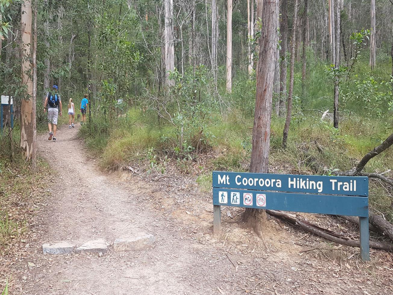
Trail 5 is a 8.8 km Trail from Cooran to Pomona, with wonderful views of Mount Cooran and the imposing Mount Cooroora, a 446m Volcanic plug right next to Pomona.

The trail as marked is a sub section and side variation of Trail 5. It is mainly open dry forest with some hills and fun little bits of single track, especially for mountain biking.

This trail can also be accessed from Jampot Creek Road near the Mount Cooroora car park on the Pomona side, for a longer adventure.

Aside from the NTN, there are multiple longer trails to be explored in Tuchekoi National Park, making this an ideal spot for those who want to get away from it all.

If Horse Riders decide to do the full Trail 5, then take care when crossing the railway lines at both Cooran and Pomona.

AFTERWARDS
Explore one of the other side trails within Tuchekoi National park – you may as well, you are right here.

The closeby vintage retro town of Cooran is definitely an added attraction with some great coffee shops and curios.

Pomona also has coffee shops, a pub, supermarket and antique shops of interest.

glossary button
Glossary
  • Icon showing this activity is suitable for wheelchairsSuitable for wheelchairs
  • Icon showing this activity is suitable for walkingSuitable for walking
  • Icon showing this activity is suitable for recreational cyclingSuitable for recreational cycling
  • Icon showing this activity is suitable for mountain bikingSuitable for mountain biking
  • Icon showing this activity is suitable for horse ridingSuitable for horse riding
  • Icon showing this activity is suitable for kayakingSuitable for kayaking
  • Icon showing this activity has drinking water availableDrinking water available
  • Icon showing this activity does not have drinking water availableNo drinking water available
  • Icon showing this activity has a barbeque on siteBarbeque on site
  • Icon showing this activity has a picnic table on sitePicnic table on site
  • Icon showing this activity has toilets on siteToilets on site
  • Icon showing fires are permitted at this activityFires permitted
  • Icon showing fires are prohibited at this activityFires prohibited
  • Icon showing camping is permitted at this activityCamping permitted
  • Icon showing camping is prohibited at this activityCamping prohibited
  • Suitable for walking Suitable for walking black lines Suitable for walking
  • Suitable for recreational cycling Suitable for recreational cycling Suitable for recreational cycling
  • Suitable for mountain biking Suitable for mountain biking Suitable for mountain biking
  • Suitable for horse riding Suitable for horse riding Suitable for horse riding
  • No drinking water available No drinking water available No drinking water available
  • Fires prohibited Fires prohibited Fires prohibited
  • Camping prohibited Camping prohibited Camping prohibited
Write a review

Be the first to review this trail.

hazard icon

IN AN EMERGENCY DIAL '000'.

Always Adventure Safely!

  • Always follow any local signage, it contains key information and conditions can change at any time.
  • Use the trails with consideration for your abilities, be prepared for the adventure ahead:
    • Be aware of the weather conditions, found here: http://www.bom.gov.au/qld/.
    • Always wear appropriate clothing, focus on good footwear.
    • Always bring more water than you think you will need.
    • Be Sun Safe!
    • Always let someone know where you are going that isn’t going with you.
  • Just getting started try this site for good useful information: https://www.trailhiking.com.au/hike-safety/
  • Sunshine Coast Council does it’s best to maintain current information but things can change so always be aware that a trail may not be as listed in this guide, and report and issues via our feedback link.

Qld Parks and Wildlife Service

National Parks, Conservation Parks and some State Forests are managed by Queensland Parks and Wildlife Service. Contact details are: https://www.des.qld.gov.au/contactus/

For current information on trail conditions and alerts go to https://parks.des.qld.gov.au/park-alerts/#sunshinecoast

If you think something on this web site needs to change please let us know via: adventure@sunshinecoast.qld.gov.au

Nearby Trails

Trail Image for Tuchekoi National Park: Pomona side trail
Intermediate

Tuchekoi National Park: Pomona side trail

POMONA
walking icon mountain biking icon horse riding icon
Trail type
difficulty icon
Skill Level

5.2km

Length
direction icon
One-way
Trail Image for Tuchekoi National Park: Mount Cooroora
Difficult

Tuchekoi National Park: Mount Cooroora

POMONA
walking icon
Trail type
difficulty icon
Skill Level

1.2km

Length
direction icon
One-way
Trail Image for Road Cycle Route: SCC Big Loop
Difficult

Road Cycle Route: SCC Big Loop

Alexandra Headland
walking icon cycling icon
Trail type
difficulty icon
Skill Level

180.6km

Length
direction icon
Circuit
Trail Image for Tewantin National Park: Lake MacDonald North.
Intermediate

Tewantin National Park: Lake MacDonald North.

LAKE MACDONALD
walking icon mountain biking icon
Trail type
difficulty icon
Skill Level

6.6km

Length
direction icon
Circuit
Trail Image for Lake MacDonald: Canoe/Kayak
Easy

Lake MacDonald: Canoe/Kayak

LAKE MACDONALD
canoeing icon
Trail type
difficulty icon
Skill Level

4.9km

Length
direction icon
Circuit

Share this trail

This action requires a login.
To continue, click on Login/Signup below.

Photo uploaded successfully, thank you.

Feedback / Suggest an Adventure

If you have any feedback on the site or any of the trails, please drop us a short email.

Have we missed something? Do you have an adventure to suggest? Fill in the suggestion form to let us know about it.